

In a new Mercury series, BEN LANGFORD investigates how new flood zones wash some residents off the map.
Subscribe now for unlimited access.
$0/
(min cost $0)
or signup to continue reading
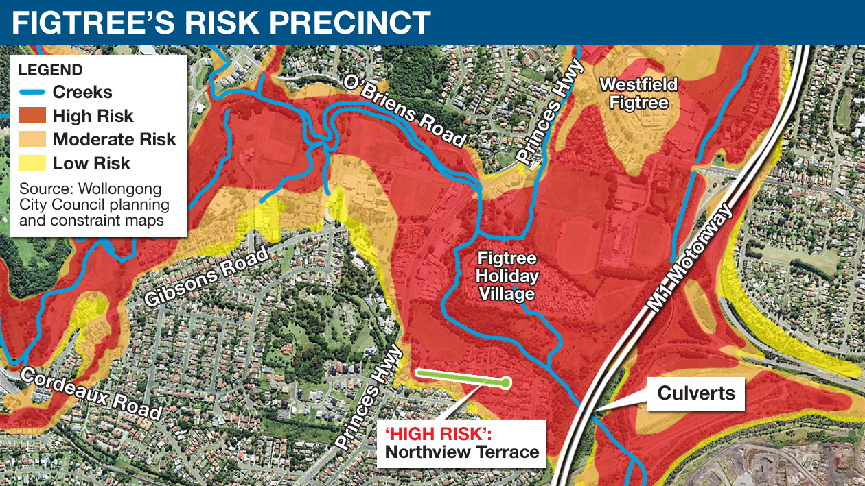
An entire street in Figtree has been swamped by insurance premium hikes of more than 500 per cent after the neighbourhood was listed as a high risk flood zone - even though these properties have never flooded.
Residents of Figtree's Northview Estate are now being quoted up to $10,000 for insurance policies that cover flooding, compared with $1600 two years ago.
Even the major flood of 1998 did not touch these residents' floorboards, but they have found the value of their properties falling and renovations hard to get approved because of the flood zoning in Wollongong City Council's latest maps.
It is a pattern being felt in other parts of the local government area as well, as residents accuse the council of "privatising the risk" while easing its own responsibility for flood mitigation.

The Figtree residents are preparing to challenge their flood zoning and have offered a range of solutions that would help alleviate the problem.
The heart of the issue, they say, is the council's culvert blockage policy, which is used in computer flood modelling.
American Creek flows through Figtree and passes under the M1 motorway in a series of eight culverts, each 3.5 metres by 3.6 metres.
But any culvert or drain that is less than six metres across is regarded as being 100 per cent blocked when the flood modelling is done.
Flood management plans are based upon these models and are the foundation of the council's flood zoning maps.
Culvert blockage was identified as a major contributor to the 1998 flooding that devastated parts of Wollongong and the council was among the first to address the issue.
But residents say assuming large drains will be 100 per cent blocked is not realistic - because it assumes a one-in-100-year flood will have the same effect on culverts as a one-in-20-year flood.
Residents can understand a cautious approach to blockages, but say it appears all the responsibility - and expense - of dealing with flooding has been levelled at them.
When Northview resident John Mathieson bought his house, it came with a certificate stating "no flooding has occurred here nor is it suspected".
The flood zoning's "crude logic", Mr Mathieson said, was shown in the fact his street was assumed to be inundated not just in a one-in-100-year flood, but also a 50-year flood, down to a 20-year flood. All because of the assumption the culverts would be completely blocked.
"This is not in accord with reality," Mr Mathieson said.
"In the most severe floods here, the blockage was judged to be 70 per cent.
"With 70 per cent blockage and near 100-year rainfall, we weren't flooded.
"The Westfield shopping centre, which actually did flood in 1998, is deemed as moderate risk. But we, who have never flooded, are deemed high risk."
The residents have formed the Northview Estate Flooding Residents Action Group and pressed their case for reform to the council in a meeting held last week.
Group convener Margaret Kulig said when the estate was constructed in the 1990s, all the blocks were levelled then built up so the floor level would be half a metre above the level of a one-in-100-year flood.
But now the estimation of that flood height has changed, so they find themselves under an imaginary metre of water, present in the council's flood risk modelling.
"The goalposts have now been moved," she said.
"Houses in this street used to sell in days, now they're taking months."
Mr Mathieson said his insurance policy had jumped from about $1600 to $7500 a year and others had received higher quotes that were simply unaffordable.
"There are very few who are now taking policies that include flood cover," he said.
Resident Rod Lynne, 79, has lived in the estate for 10 years. He said the changes were "immoral".
"There's not a person in this estate ever had a claim for stormwater or floodwater," he said.
Michael Nicolaidis, whose property is at least one metre lower than others nearby, said the 1998 floods did not affect him.
"Not even close," he said. "The back steps didn't even get wet."
Residents willing to help find solution

Not only has the Figtree residents’ group identified the problem with flood modelling, they have also come up with a series of ‘‘cost-effective solutions’’.
John Mathieson, a retired scientist who used to work at the steelworks, has developed a suite of options to alleviate the problem, either perceived (according to the flood modelling) or actual – if water does actually rise that far.
First, he said, is a revision of the council’s blockage policy to better reflect recent research and the experience of real flood events.
Other solutions he has proposed assume the retention of the blockage policy, but can be constructed regardless.
They include:
- a debris control structure upstream of the culvert under the M1, to catch water-borne debris and reduce blockage
- construction of additional shallow-lying culverts large enough to let large objects through, and more than six metres across the diagonal (to deal with the blockage policy)
- minor earthworks to direct American Creek over the lowest point in the M1 – this would allow water to escape before it reached homes
- a levee to protect homes – built near American Creek south of the retention basin.
Related stories:
